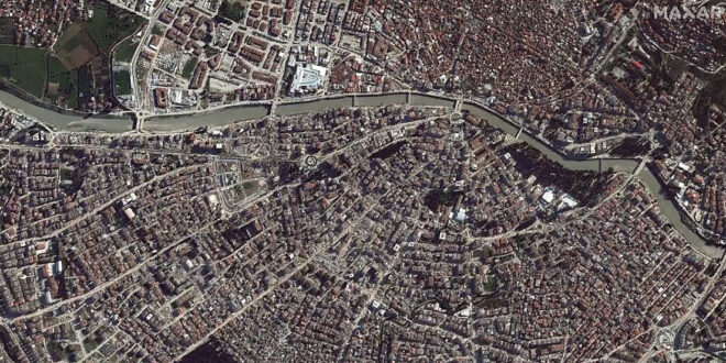
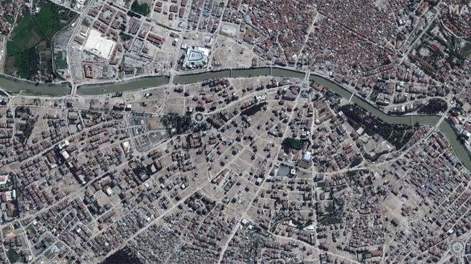
Deprem sonrası Antakya’daki yıkımı gösteren üzücü görsel
Yurt dışı merkezli uzay ve teknoloji firması Maxar, deprem bölgelerinin uydudan çekilmiş görüntülerini paylaşmayı sürdürüyor.
Maxar, yaşanan inanılmaz büyük depremler sonrasında Türkiye’yi Açık Veri Programı kapsamına aldı. Firma bu program kapsamında kurtarma çabalarını desteklemek adına, depremden etkilenen alanlara ilişkin verileri ve fotoğrafları elde ettikçe kamuya açık olarak paylaşıyor. Bu bağlamda şimdiye kadar çok sayıda uydudan çekilmiş görüntü ve veri paylaşan firma, yaşanan yıkımı öncesi ve sonrası görseller ile gözler önüne sermeye devam ediyor. Bu sefer bu konuyu gündeme getiren ise Antakya’daki yıkımı gösteren sayfadaki üzücü görseller oldu. Yukarıdaki galeride ya da hemen aşağıdaki Tweet içerisinde görebileceğiniz bu görseller, enkaz kaldırma çalışmaları sonrasında oluşan kahredici “boşluğu” net olarak gösteriyor. Bu boş alanların önümüzdeki aylarda daha da artması bekleniyor çünkü halen bölgede yıkılmayı bekleyen çok sayıda bina yer alıyor, halen enkaz altında cesetlerin olduğu dahi aktarılıyor. 50 binden fazla insanımızın hayatını kaybettiği depremler, bölgeyi genel olarak adeta bir savaş alanına çevirmiş durumda.
In Antakya, Turkey, substantial sections of the city were reduced to rubble due to the February 2023 earthquakes. This before/after satellite imagery from @Maxar shows parts have been cleared. Horrifying to see. pic.twitter.com/gu8dC0eFM0
— Christiaan Triebert (@trbrtc) April 6, 2023
İLGİNİZİ ÇEKEBİLİR
Firmadan bundan önce gelen görsellerde bir toprak kaymasının dağ yolunu kapatması, çok büyük bir yangın yaşanan İskenderun limanı ve Kahramanmaraş şehir merkezindeki çok üzücü yıkım ile fazlası karşımıza çıkarılmıştı.
Recent #satellite imagery shows a #landslide that was triggered by the #earthquake, blocking a mountain road. This is near the town of #Islahiye in southeastern #Turkey (location: 37.002, 36.594). The before image is from December 27, 2022 and the after from February 13, 2023. pic.twitter.com/2MG7CRbiQH
— Maxar Technologies (@Maxar) February 13, 2023
The southern Turkish port of #Iskenderun (location: 36.593, 36.191) suffered severe structural damage, as well as container fires, from the recent #earthquake with overall operations halted and all ships diverted to alternative ports. Satellite image from Feb 12, 2023. #Turkey pic.twitter.com/DIGoKZ4XD1
— Maxar Technologies (@Maxar) February 13, 2023
New #satellite imagery from today, February 13, 2023, of #Kahramanmaras, #Turkey, showing the aftermath of the recent #earthquakes. Extensive building damage with debris removal operations in process can be seen, along with temporary shelters in the area. pic.twitter.com/HjEhtbTBmk
— Maxar Technologies (@Maxar) February 13, 2023
The recent #earthquake also destroyed grain silos, as seen here in the towns of #Kirikhan (left) and #Nurdagi (right), #Turkey. #Satellite images from February 9, 2023. pic.twitter.com/Vm9dZXWEw7
— Maxar Technologies (@Maxar) February 10, 2023
In this #satellite image, from February 9, 2023, you can see visible damage from the recent #earthquake to the runway at the Hatay Airport in the Hatay Province, #Turkey, with construction equipment making repairs. pic.twitter.com/xfex11kntk
— Maxar Technologies (@Maxar) February 10, 2023
Near the epicenter of the #earthquakes, in the city of #Nurdagi, #Turkey, a significant fault line rupture can be seen cutting across a highway, farms and residential areas.
1.) Before: September 6, 2019
2.) After: February 7, 2023
3.) After with visual graphic pic.twitter.com/6uHuf2bcWr— Maxar Technologies (@Maxar) February 10, 2023
Hepsi direkt olarak burada yer alan ve sürekli olarak güncellenen fotoğraflar, eğer doğru kullanılabilirse kritik karar verme süreçleri ve planlama çalışmaları kapsamında çok faydalı olabilir. Şirket, Açık Veri Programı aracılığıyla dağıtılan tüm görüntüler ve verilerin Creative Commons Attribution Non-Commercial 4.0 lisansı (CC BY-NC 4.0) altında lisanslandığını belirtiyor. Bu lisanslama, bilgilerin / görsellerin ticari olmayan kullanımına izin veriyor ve kâr amacı gütmeyen kuruluşlar tarafından rahatlıkla kullanılabiliyor. Maxar tarafından daha önce paylaşılan görseller:
New satellite images from today, February 8, of areas in #Antakya, #Turkey that have been heavily affected by the recent #earthquake. Damage can be seen throughout the area, particularly with numerous high-rise apartments buildings that have collapsed. pic.twitter.com/zhK9WnJYtS
— Maxar Technologies (@Maxar) February 8, 2023
We will be activating our Open Data Program (https://t.co/KG4Ln7Gvck) for the powerful #earthquakes in #Turkey and #Syria. Please stay tuned for that notification. Seen here is another before (Oct 4, 2022) and after (Feb 7, 2023) view of #Islahiye, Turkey and the destruction. pic.twitter.com/jd8KakGRgb
— Maxar Technologies (@Maxar) February 7, 2023
We are working with multiple organizations to provide them with #satelliteimagery of the recent #earthquake that has devastated #Turkey & #Syria. Seen here are before (Oct 4, 2022) & after (Feb 7, 2023) images of #Islahiye, Turkey, showing collapsed buildings & rescue operations. pic.twitter.com/3c69oZFYmu
— Maxar Technologies (@Maxar) February 7, 2023
Our latest images from the #earthquake in #Turkey. Weather and cloud cover have been a factor in obtaining new imagery of the affected areas. We will be releasing new imagery as we get it. Seen here is a before (Oct 4, 2022) and after (Feb 7, 2023) overview of #Islahiye, Turkey. pic.twitter.com/CAvQvjb1bZ
— Maxar Technologies (@Maxar) February 7, 2023
Geçtiğimiz dönemde NASA’dan hemen aşağıdaki paylaşım da gelmişti. Burada renkler üzerinden yıkımın seviyesi gösterilmişti.
NASA and other agencies are using satellites to map damage caused by the 7.8 and 7.5 earthquakes in southern Türkiye and western Syria on Feb. 6. https://t.co/C7jWcow5Gn
— NASA Earth (@NASAEarth) February 10, 2023


